Road Trip 2011: The Great American Road Trip

Back in the summer of 2011, my sister Melissa and I embarked upon a 6500+ mile-long road trip across the United States. We started in northeast Ohio, and drove all the way to Las Vegas and back.
This was our first big US road trip, and we did it in the days when we still printed off MapQuest directions and burned CDs to listen to in the car. Social media didn't exist like it does today, so I decided to share a daily, diary-style blog post with a video every day of our nearly-3-week trip!
I've consolidated all of those posts here, mostly to preserve my own memories of that trip.
All of the text was written in July/August 2011.
If you want to read more useful road trip content I've written, check out these posts:
- 15 Biggest Mistakes People Make on a US Road Trip
- US Road Trip Packing List: All the Essentials to Drive Across the USA
- US Road Trip Itineraries
Road Trip Day 1 – Racetracks and Santa Claus
Road Trip 2011 started off with a bang! Day One took us across multiple state borders (5 states in all — Ohio, Kentucky, Indiana, Illinois and Missouri), down many highways, and on only a few wrong turns.
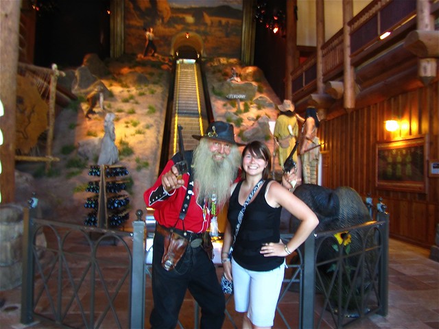
We began the day in Findlay, Ohio, and headed south down to Louisville, Kentucky, where we visited Churchill Downs and the Kentucky Derby Museum. I've been a fan of horses since I was very young, and I was mildly obsessed with horse racing for a few years in middle school. So, for me, a visit to Churchill Downs, where the Kentucky Derby has been run for 137 years, was really exciting.

We took a behind-the-scenes tour of the racetrack, and then had time to explore the Kentucky Derby Museum, which, considering its compact size, is actually pretty great. It's colorful, informative, and interactive — all good traits for a museum to have. Even if you don't like horses or racing very much, I think this museum would still be fun.
Here are a few photos from Churchill Downs:


From Louisville, it was on to St. Louis, Missouri, via quite a few states. But, along the way, we couldn't ignore the signs for Santa Claus, Indiana. Yes, you've got it — a Christmas-themed town in the Midwest!
We obviously had to stop and drive around this odd little town, posing with a few Santa statues and giggling like mad at the absurdity of all the Santa-themed shops and the twinkle lights strung up in August. My favorite part though? The police cruisers announcing the “Santa Claus Police.”


After a long day of driving, we finally arrived in St. Louis to see the city all lit up at night. Hopefully fun adventures await us here tomorrow!
Each day, I'll be cutting together a quick video to show you what we've been up to. Here's Day 1:
Road Trip Day 2 – Melting in St. Louis
Very little of Day 2 of our road trip was actually spent on the road. In fact, most of it was spent OFF the road, in the oppressive St. Louis heat. Seriously, it should not be allowed to be this hot and humid.
After a late start to the day, Melissa and I went with Scott (our lovely host in St. Louis) for burgers with another travel blogger. We went to Blueberry Hill in “The Loop” section of the city, which is kind of hip and funky and full of character. The burgers were delicious, and the place was close to the Metro station.

Which was good, since our next stop was the Gateway Arch downtown.
Melissa and I hopped on the Metro and headed to the Arch, which, as it turns out, is actually part of the Jefferson National Expansion Memorial — run by the National Park Service. Too bad I left my National Parks pass in my car. Oops.
The Arch is extremely impressive in person, towering 630 feet over the Mississippi River, with the city of St. Louis as a backdrop.


We paid the $10 to take the tram to the top of the Arch, which was an experience in itself. In order to get to the top of the curvy structure, you have to crawl (literally, crawl; the doors are only about 5 feet high) into this little pod-like contraption, which then shimmies its way up the interior of the Arch.
At the top, little rectangular windows offer you views out over St. Louis on one side, and the Mississippi River and Illinois on the other.

After riding the tram back down to ground level and taking a stroll through the Western Expansion Museum, Melissa and I headed back outside for some silly photos with the Arch. Was this my favorite (and sweatiest) part of the day? You bet.


Then it was back to Scott's place for some famous Ted Drewes Frozen Custard. I got a “raspberry brownie concrete” (the “concrete” part meaning it was thick), and it was delicious.


All in all, a good day in St. Louis, even if I did almost melt into a puddle several times.
Each day, I'll be cutting together a quick video to show you what we've been up to. Here's Day 2:
Road Trip Day 3 – Exploring Caves and Remembering Joplin
After bidding farewell to St. Louis, we headed west on I-44 on Day 3, taking short jaunts on old Route 66 just for fun (or should I say just for kicks?) from time to time. We had no real plans for the drive, but ended up making a few memorable stops (including having our first meal at Sonic!).

Exploring Caves
Our first stop of the day was in Stanton, Missouri — home to the Meramec Caverns.
If you are driving anywhere in this area — hell, anywhere in Missouri, even — you can't miss the endless advertising for this natural attraction. There were billboards every half mile or so for at least an hour before we reached Stanton. In fact, I've even seen ads painted on the roofs of barns as far north as Ohio for these caves.

When it comes to something so heavily advertised, there's always a fear that it won't actually be worth the admission fee. Well, with the exception of perhaps the $50 zip lining over the parking lot, I think the Meramec Caverns ARE worth the admission fee. $20 gets you an hour-and-a-half-long guided tour into the depths of the caverns, where you'll see everything from underground rivers to slimy stalactites and stalagmites.
The tour was interesting enough to even keep the young children in our group quiet most of the time.

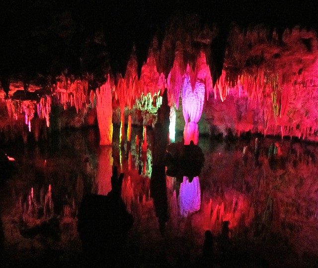
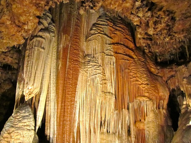
And the added bonus? The caves are a constant 60 degrees Fahrenheit, which is a nice respite from the current 100-degree temperatures outside.

But then came the more serious part of the day.
Remembering Joplin
I knew I-44 would take us through Joplin, the Missouri town that was devastated by an EF-5 tornado on May 22, 2011. At least 160 died in Joplin that day, and thousands more were displaced from their homes as a tornado a mile wide ripped through town.
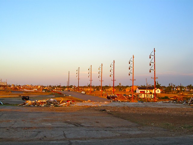
After having visited Christchurch, New Zealand, 3 months post-earthquake earlier this year, I knew that making a stop in Joplin was important. Important because, with disasters like this, people tend to forget about the “after” portion of the event. Once the quake or tornado or famine falls off the front pages of our newspapers, we tend to forget that they ever happened — even though the people affected are still living through it. So it was in Christchurch, and so it was, too, in Joplin.
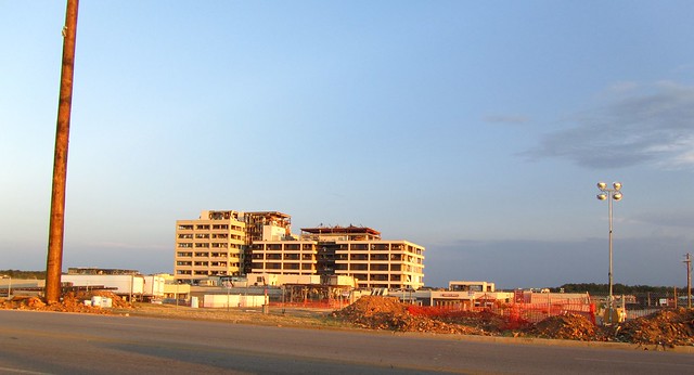
Joplin almost felt like a ghost town. Tented relief centers are still set up on the outskirts of the city, and the tornado's path through populated areas can still easily be traced. Joplin is FAR from recovered, even if we aren't hearing much about it anymore.
I could go on and on about how surreal it was to drive down Joplin's deserted streets, or how heart-stoppingly sad it was to see destroyed homes, but I think these photos can say it much better:


Today, I ask you to remember Joplin. And Christchurch. And Japan. And every other country or city that has been affected by a natural disaster this year. Just because the media isn't covering it anymore doesn't mean that these places are back to “normal.” They still need your thoughts, prayers, and help. If you want to donate to any of these disasters, consider making a donation to the Red Cross.
Each day, I’ll be cutting together a quick video to show you what we’ve been up to. Today I made two, because I felt like Joplin deserved its own video.
Here's the first one:
And here's the second, dedicated to Joplin:
Road Trip Day 4 – Onward Through Oklahoma
After an overnight stay at the ultra-modern, somewhat-swanky Aloft Tulsa, we headed out into Oklahoma (where, yes, the wind really DOES come sweeping down the plains, as evidenced by the large numbers of windmills alongside the highway).

Our first stop of the day was in Oklahoma City.
I had heard good things about the Oklahoma City National Memorial and Museum — which was put in place to remember the 168 people who died in the Oklahoma City bombing in 1995 — and decided we should check it out. Had I known how great and thorough this museum was, we would have been sure to allow for more time there.


As it was, we spent about 15 minutes walking around the outdoor memorial itself, which sits on the former site of the Alfred P. Murrah Federal Building — the target of the April 1995 bombing. The most touching part of the memorial is the long rows of chairs that symbolize the victims of the attack.


Because my sister and I were both quite young when the bombing happened (my sister wasn't even 4 yet), we didn't know very much about it. I knew more about the aftermath, but very little about the events of April 19, 1995. So we decided to pay the $8 entry fee to go into the museum.
Knowing what I know now about the museum experience, I would have gladly paid much more.

The Oklahoma City National Museum is probably one of the most memorable museums I have ever visited. It's not very large, but it is very detailed. And very visual.
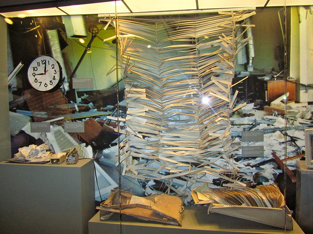
The museum experience takes you on a chronological, hour-by-hour journey through the events leading up to, during, and after the bombing. The museum's rooms are filled with things salvaged from the wreckage, photos, and video interviews with survivors, rescue workers, and others who talk about the attack and its aftermath.
It's evident that a lot of care went into this museum, and I think that made it all the more impactful. I know I teared up quite a few times.

I think we've had our fill of sad, reflective spots for now, however. Between Joplin yesterday and Oklahoma City today, I think I've reached my quota for sobering experiences this week.
So what did we do next? Stop at a random rest area along I-40/Route 66 that advertised Cherokee artwork, Oklahoma souvenirs, and a real live buffalo, of course!
It did not disappoint, either, even if we never did see that live buffalo…

Each day, I’ll be cutting together a quick video to show you what we’ve been up to. Here's Day 4:
Because we spent roughly 3 and a half hours in Oklahoma City and then another hour at the Cherokee Trading Post, we didn't arrive in Amarillo, Texas, until after dark. So all of our Amarillo adventures (and oh, there WILL be adventures!) will have to wait until tomorrow.
Road Trip Day 5 – Vandalism and a Taste of Texas
Since we arrived in Amarillo quite late on Day 4, we saved all of our Texas fun for Day 5. And was there ever fun to be had!
We first headed West on I-40 about 10 miles, where, off the I-40 access road, sits one of the most popular roadside tourist attractions in the U.S. — the Cadillac Ranch.

This oddball attraction has been around since 1974, when a local Texas millionaire decided Amarillo needed a different kind of funky art installation. A handful of old Cadillac cars were then buried, nose-down, in an unused field. And, somehow, this random attraction has become a Route 66 favorite.

Today, visitors are encouraged to cover the cars in all manner of graffiti.

Unfortunately, not everyone picks up after themselves…

My sister and I had fun leaving our own marks on the cars, though:


After half an hour or so out in the hot Texas sun, we were ready for some lunch. And what better place to go in Amarillo for a bite to eat than the Big Texan?

This roadside diner simply cannot be missed — literally, there are so many huge signs for it that you'd have to be blind to not notice it from the highway.

The Big Texan itself resides in a garishly yellow building with a giant longhorn cow and cowboy boot on display outside. There's also a colorful motel (complete with a pool shaped like the state of Texas), and a place to board horses for the night.

And, while the Big Texan IS known for being a kitschy roadside attraction, it's probably most well-known for its 72-ounce steak challenge. During this challenge, brave souls are given an hour to eat a 72-ounce steak, a salad, and a bunch of sides. Two people were taking the challenge while my sister and I were there (see the video for this). I don't think I've ever seen such a large piece of meat in my entire life. It was almost scary.
I stuck to a nice 8-ounce prime rib.

After our lunch (during which we were even serenaded by a roving country singer!), we checked out the gift shop and other fun areas of the Big Texan (such as a shooting gallery, bar, maze, and fudge shop). I picked up some very special band-aids, which I think are my favorite purchase of the entire trip so far:

Eventually, though, it was time to hit the road again. Santa Fe was our destination for the night, and it was on the way there that we finally started seeing some of the bluffs, scrub brush and big skies that I have always associated with “the West.”


Each day, I’ll be cutting together a quick video to show you what we’ve been up to. Here’s Day 5:
Road Trip 2011 – Day 5 from DangerousBiz on Vimeo.
Road Trip Day 6 – New Mexico is Surprisingly Awesome
I'll admit that New Mexico was not really a state I was looking forward to on this road trip. In fact, in my first post about my road trip plans, I basically wrote it off as just a passing-through state, assuming that there wasn't much here beyond a lot of turquoise jewelry.
Well, how wrong I was!

After getting a lot of tips from readers to skip Albuquerque, my sister and I opted, instead, for the capital of Santa Fe. I was a bit skeptical that a state capital could really be cool, but once again New Mexico proved me wrong. Santa Fe is tiny by most standards (around 80,000 people, I think), and is far from feeling like a government seat.

Instead, Santa Fe is funky, colorful, and at least a few decades behind the rest of the country. In fact, the owner of the Western-themed Silver Saddle Motel (the great little local place where we stayed), said that Santa Fe embraced the hippie movement of the 1960s, and never really let it go. They are just now witnessing the phenomenon of plastic truck testicles.
But lagging a bit behind is by no means a bad thing. In fact, Santa Fe was great. I really regret not allowing more time here.

As it was, we woke up on Day 6 and headed down to the Railyard district of the city, where there was a farmer's market going on.


After getting our fill of Santa Fe sights and sounds, we hopped on the highway and headed about half an hour north of the city to check out Pecos National Historical Park, which we had seen photos of in a Santa Fe tour book. This National Park is not only cheap ($3 will get you onto the trails), but also beautiful. Stopping was a no-brainer.

Since we were on a tight time schedule, we spent about half an hour walking around the Pecos Pueblo ruins in the park, and also explored an old Spanish Mission. The red clay bricks contrasting sharply with the greens and blues of the surrounding hills and the dark clouds of an incoming storm was simply stunning.


Then it was on through New Mexico, with our final destination being the Valley of the Gods in southern Utah. I expected this drive to be sort of dry and boring, but again New Mexico had surprises in store.
As we drove north, we were greeted by towering bluffs, tree-covered mountains, and a very colorful desert. I had no idea northern New Mexico was hiding all of this!


After a rather long drive, we finally crossed the border into Utah on a narrow two-lane road. I was excited because we FINALLY got to take a photo with a “Welcome to” state sign!

The sun was setting as we snaked our way into the Valley of the Gods, painting the sky brilliant hues of orange, gold and purple. I already feel a little flutter for Utah. I think this could very well turn into a love affair.

We arrived at dusk at the Valley of the Gods B&B, which is located down a dirt access road that's only navigable in dry weather — good thing there was no rain in the forecast! The B&B is totally off-grid, and is solar- and wind-powered. It also was gorgeous, and gave a remarkable view of the night sky — including the Milky Way!
Melissa and I climbed down into our “cave” (our bedroom was underground), and turned in early in preparation for Day 7.
Each day, I’ll be cutting together a quick video to show you what we’ve been up to. Here’s Day 6:
Road Trip Day 7 – Floating Over Monument Valley
Monument Valley, Utah, was not in our original road trip plans. It was too far south, and not really “on the way” to any of the stops we were making.
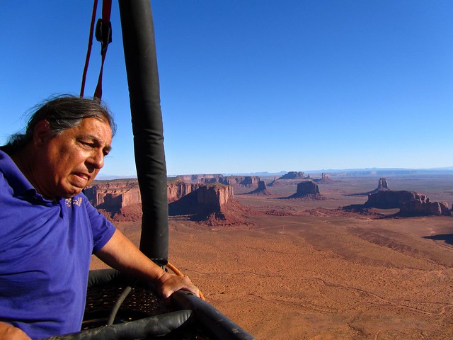
But then I found out you could take hot air balloon flights over the valley. We had to rethink our plans.

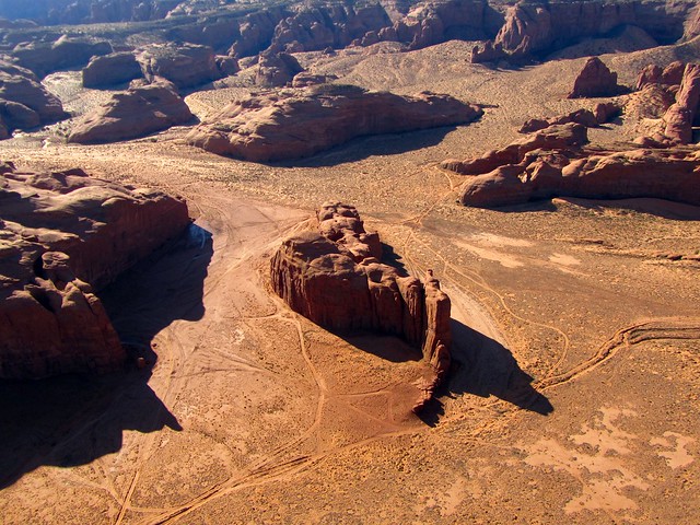
We woke up before the sun rose on Day 7 to make the 45-minute drive from the Valley of the Gods to the Monument Valley tribal park. The valley is located on Navajo lands, which is the only thing that prevents it from being named a National Park.


We met up with our balloon pilot Frank from Monument Valley Balloon Flights, Navajo guide Gabriel from Majestic Monument Valley Touring Co., and driver Danner at The View hotel, which — true to its name — offers sweeping views out across Monument Valley. Of course, when we arrived, the sun wasn't yet above the horizon.

Our little team headed into the park on a rather rough unpaved road (I would not suggest taking your tiny sedan through this park), and stopped to watch the sun rise between the Two Mittens. Every rock formation in Monument Valley has a name — and usually a story — and Gabriel pointed them all out as we traversed through the park.

There are the Three Sisters:

Artist's Point:

Totem Pole and the God Heads:

Many Westerns have been filmed out here (it was a favorite location of John Wayne's), as well as scenes from Mission Impossible and countless car commercials. It's not difficult to understand why — the scenery definitely leaves an impression.

Eventually, after stopping to check the wind direction a few times, we came to a clear spot that would serve as the launching point for our hot air balloon. Frank, Gabriel and Danner set to work unfurling and inflating the balloon. It was actually a pretty fascinating process.


And then, before we knew it, Melissa and I were climbing into the basket and rising into the air.


The balloon ride was smooth and rather warm, and the views we got from 7,000 feet up were indescribable. Instead of writing about them, I'll just show you:


Landing was not quite as easy as taking off, but eventually Frank set us down on a bit of uneven road, and the guys began wrestling with the balloon to get it packed away. While this was going on, Melissa and I were treated to a little breakfast, complete with sparkling cider (it's customary to carry champagne on any hot air balloon ride, but since we were on a Navajo reservation where alcohol is prohibited, we settled for cider).

Next it was off on a short backcountry tour, with stops at various natural arches.
The Sun's Eye:


Ear of the Wind:

Big Hogan:

Our last stop on the tour was at John Ford's Point, which is said to be one of the director's favorite spots to film in Monument Valley (his most notable film, in case you don't recognize the name, is probably “Stagecoach”).

Not quite ready to leave Monument Valley just yet, Melissa and I headed into The View for lunch at their restaurant. We both got Navajo Tacos, which are served on fluffy blue-corn frybread. Yum!

After a few more photos in the early afternoon light, it was finally time to bid Monument Valley (and Utah, for the time being) farewell.


Each day, I’ll be cutting together a quick video to show you what we’ve been up to. Here’s Day 7:
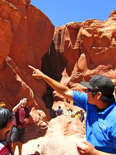
Road Trip Day 8 – Adventures in Antelope Canyon
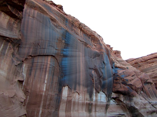
Have you heard of Antelope Canyon before? Chances are probably about 50/50 that you have. But the odds increase substantially that you've seen photos of the slot canyon before, even if you didn't know it.

Antelope Canyon, located on Navajo land near Page, Arizona, has become a bit of a mecca for photographers, owing to the famous light beams that shine down into the narrow canyon during certains times of the day.

When planning this road trip, I knew Antelope Canyon had to make it into our itinerary somehow. I knew it would be too good to miss.
And I think I was right.

The slot canyon portion of Antelope Canyon can be accessed in two different spots, across the road from one another — Upper Antelope Canyon and Lower Antelope Canyon.
Upper is the more famous of the two (because of those light beams), and is therefore much more crowded. Lower, by contrast, is much less-visited. It is also a more adventurous canyon, with more hiking and climbing involved within it.
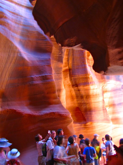
As much as we would have liked to visit both sections of Antelope Canyon, we only made it to Upper. We started out there at about 11 a.m., hoping to catch the light beams before they started disappearing once the sun rose to the middle of the sky just past noon.
Since Antelope Canyon is owned by the Navajo Nation, it requires an entry fee, and a paid guide. The Upper canyon cost $31 per person total, which included a $25 fee for the guided canyon tour, as well as a $6 Navajo fee. In my opinion, it was worth the entrance fee.

We arrived at the Upper canyon around 11 a.m., but it was so crowded that we missed out on the 11 .m. tour and were booked on the noon one instead. About 15 minutes before noon, we were all piled into modified pick-up trucks and taken on a (very bumpy) 15-minute ride to the slot canyon. I would NOT recommend this for anyone with a bad back…

After arriving at the canyon, our group of 12 was led through by our Navajo guide, who pointed out rock formations, told us about how the canyon was formed, and instructed us on how to take some great photos. While the hour-long tour was great and the canyon itself was stunning, I won't sugar-coat it — the canyon was CROWDED, full of people snapping photos.
But, despite that, I still think it was worth it. And here's why:


After our tour, we had a lazy day in Page. Around 6 p.m., we made our way out of town and down to Lake Powell, which is a gigantic lake that sits in the basin of Glen Canyon. The lake is designated as a National Recreation Area, and offers just about any type of water sport you can imagine.

We opted for a cruise on the lake through the above-ground portion of Antelope Canyon.


The sun was setting as we sailed between the canyon walls, which painted the tops of them a brilliant gold color.


Page is definitely a place I'd love to return to someday. There's so much to do and see here, and we barely scratched the surface.

Each day, I’ll be cutting together a quick video to show you what we’ve been up to. Here’s Day 8:
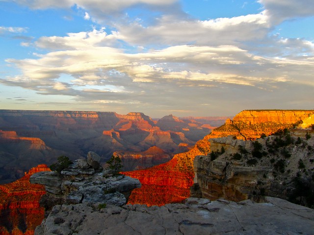
Road Trip Day 9 – The Grand Canyon
I probably don't even need to say this, but the Grand Canyon really is grand. Seriously. I've seen canyons before, and I thought I was prepared for the “big one.” But I definitely was not. I was blown away.
The Grand Canyon is just so VAST. It stretches on further than the eye can see, and is deeper than I ever could have imagined. And the COLORS!
But before we get to that, how did we get to the Grand Canyon?
Originally, the plan had been to be at the North Rim for sunrise. But, at 10 p.m. the night beforehand, I simply could not fathom a whole day of driving around the canyon on only 3 or 4 hours of sleep. So, instead, we decided we'd shoot for sunset.
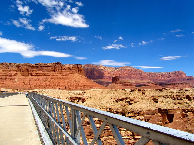
We left just after 9:30 a.m. from Page, Arizona, and began a twisting ride down a mountain and along the Vermillion Cliffs on our way to the North Rim.

Driving over the Colorado River got us excited!

Along the way, we stopped at Cavedwellers, which is a spot where a woman built a house next to the canyon that incorporates a few oddly-shaped fallen rocks in its design.


We eventually entered Grand Canyon National Park after a twisting drive through Kaibab National Forest, and were immediately greeted by a herd of buffalo!! Real, live buffalo! It was a great start to our Grand Canyon adventure.


Then, we finally arrived at the North Rim visitor's center, which is located within the rustic Grand Canyon Lodge. Instead of checking out the lodge, however, we immediately hit the trail that would lead to Bright Angel Point (the highest overlook point in the canyon), because some rain clouds were moving in and we didn't want to miss the view.
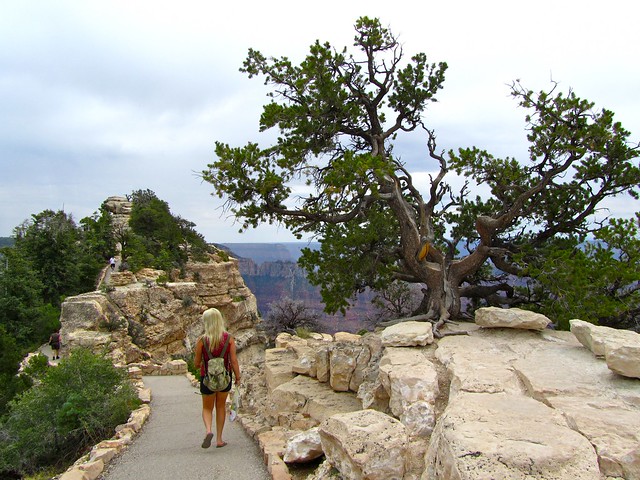
The North Rim of the Grand Canyon is much, much less touristed than the South Rim, and it was evident as we made our way along the trail. Yes, we ran into other canyon visitors. But it was by no means crowded. It was almost like we were all sharing in a secret.
So, without further ado, I present to you the Grand Canyon (North Rim):


After spending some time at the North Rim, we hit the road again for the 4-hour drive around the canyon to the South Rim. Even though many swear that the North Rim is “better” because it has less crowds, we knew we had to see both sides to judge for ourselves.
As the raven flies (and there are lots of them in this part of the country), it's less than 20 miles across the abyss that is the Grand Canyon. But the winding road has to go all the way around the canyon, and takes hours.
It was totally worth all the hours in the car, though. And it wasn't really all that crowded, either.

We arrived at the South Rim about an hour and a half before sunset, and were pleased to find that the clouds from earlier in the day had disappeared.
We first stopped at Desert View, which is the first spot on the South Rim where you can view the canyon if you're coming in from the east park entrance. There's an old watchtower here you can climb for even better views.


We also stopped at Grandview Point, which really did live up to its name.


About 15 minutes before the sun began to paint the sky pink, we made our way to Mather Point, near the South Rim Visitor Center. There are some great overlooks here, and the sunset was fantastic. Being at the Grand Canyon as the sun sank below the horizon was really quite surreal.


So, does the Grand Canyon live up to its name?
Absolutely. I already can't wait to go back someday.

Each day, I’ll be cutting together a quick video to show you what we’ve been up to. Here’s Day 9:
Road Trip Day 10 – Sliding Through Sedona
I've been to plenty of pretty cities. More than one that's made me think, “Oh yeah, I could live here.” Like Queenstown. Or Victoria, BC.
And now I may have to add Sedona to that list.

Yes, Sedona, Arizona, is pretty. There's no arguing that. In fact, it was even recently voted as one of the top 10 most beautiful places in America by viewers of Good Morning America.
I personally had no idea this little town was so picturesque. Even driving in, Sedona was deceiving — at night, the city is dark. And purposefully so. It follows nearby Flagstaff's lead with its “dark skies” law, which made the twisting drive down a mountain and into town rather harrowing. It wasn't until the next morning that I realized just how gorgeous a place Sedona is.

Situated in the Verde Valley region of Arizona, Sedona is best known for its Red Rocks. Which are pretty self-explanatory, really. And also really abundant. The color contrasts between the red rocks and vegetation are particularly stunning on a clear summer day like the one we lucked out with.

And can I just say that the uptown area is so darn cute? Because it is.


I realize that living in a tourist town of 10,000 probably wouldn't actually be all that great. But while I was in Sedona, I couldn't help but imagine looking out my window every morning to something like this:

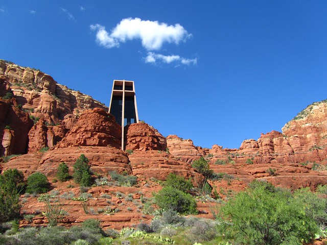
Melissa and I spent an afternoon popping in and out of shops, eating some delicious food (I seriously had the best sandwich ever at Sedona Memories Bakery Cafe), and just taking in the town. We took a tour with Sedona Trolley (surprisingly informative), and also drove out to the Chapel of the Holy Cross (surprisingly pretty).


But, as pretty as it was, within just a couple of hours, we became sluggish. Sedona is HOT in the summer. Of course, most of the Southwest is, and Sedona DOES try to combat the heat with misting fans at just about every shop entrance.
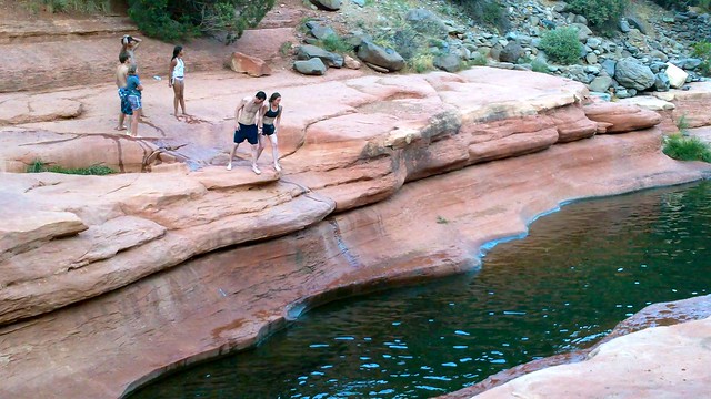
But still. It was just so hot. So we decided to go for a swim.

Next to Red Rocks State Park, the most popular place to go in Sedona has to be Slide Rock State Park. This park is named after a natural, slippery water slide that has been carved out by the waters of Oak Creek in Oak Creek Canyon. The park is popular with both locals and tourists alike, and is absolutely worth the entrance fee ($20 per car, with up to 4 people inside).


Slide Rock is the place to go if you want to entertain the kids, or if you just want to feel like a kid yourself. Seriously — I haven't had this much fun in a long time (see the video!).

I'm so glad we added Sedona to our itinerary. It was a great little city, and I hope to get to pass through again someday so I can continue daydreaming about my fantasy house in the hills.

Each day, I’ll be cutting together a quick video to show you what we’ve been up to. Here’s Day 10:
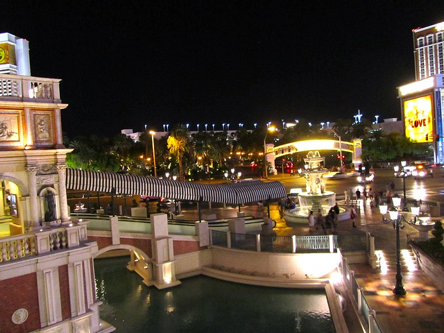
Road Trip Day 11 & 12 – What Happens in Vegas…
I could make this post incredibly short by using the old saying, “What happens in Vegas stays in Vegas.” Which would then probably make you very curious as to what Melissa and I got up to in Sin City.
However, seeing as I'm not much of a partier and Melissa isn't quite yet 21, there were very few shenanigans for us to get up to in Las Vegas.
But that definitely doesn't mean we didn't have a blast there.

On Day 11, we bid Sedona farewell and made our way into Nevada, making a pit stop at the Hoover Dam. The dam, which was built in the 1930s to help tame the raging Colorado River, is often found on lists of modern engineering marvels and new wonders of the world. And I think it does deserve its spot there. As you stand at the top of this concrete monster and look down at the Colorado River on one side and Lake Mead on the other, it's hard to believe that it was built by the hands of men. In the 1930s. Crazy!


We did not have time to take the dam tour (haha… dam tour…), but instead made the mistake of paying $8 just to go inside the Visitor Center. Don't get me wrong — there's some cool stuff to read and look at in there. But you'd be much better off getting the $11 ticket that includes both the Visitor Center AND the Hoover Dam tour.
We should have just walked/drove across the dam and got our photos that way. Oh well. Live and learn!

After the dam, we continued on over the Nevada line and on to Las Vegas. We arrived just before sunset, when the lights on the Strip weren't quite blazing yet. We checked into our hotel (the Stratosphere), grabbed some dinner inside the Stratosphere casino, and then decided to get our Vegas on.
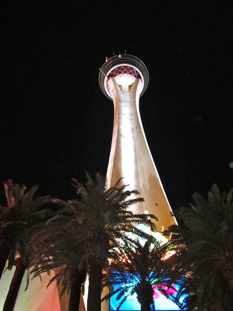
Since we were staying at the Stratosphere and had unlimited access to the observation deck at the top of the hotel's tower, we made that our first stop. We watched some people on some truly terrifying thrill rides, and took in the Las Vegas Strip sparkling in the (surprisingly) clear night air.


Then it was time to get down there. Which was easier said than done, really. We were told walking all the way to the main part of the Strip was unsafe (since the Stratosphere is at the slightly-sketchy far end of things), and we weren't about to shell out for a taxi.
Our solution ended up being a bus that runs up and down the Strip in a loop, stopping at every major hotel/casino. We paid $7 for a 24-hour pass. The price wasn't bad at all, but the downside to the bus was that it was crowded, and crawled along in traffic. I would not recommend this mode of transport if you're in a rush.
Eventually, though, we made it down into the thick of things.


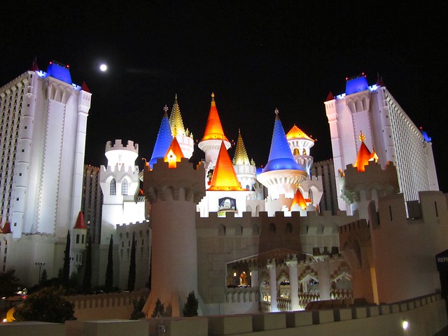
Since we couldn't get Melissa into any of the nightclubs, we simply walked up and down the Strip — from the Venetian to the MGM Grand and back. It was A LOT of walking. Thank God we weren't wearing heels.


Even though we didn't get drunk and stupid, we had fun watching others who did. Vegas is honestly probably the best place on earth for people-watching — and we certainly did our share! There were drunk people dancing, sober people trying to get drunk, people in costumes posing for photos with drunk people… yes, there's definitely a theme on the streets of Vegas.


We were both amused at the fact that you can just carry around open containers here — and that just about everybody does. We were also amused by the “escort” cards being handed out (and then dropped on the ground) everywhere, which feature mostly-naked girls with little stars covering up their naughty bits.
This theme (naked girls) was also everywhere you looked. They actually pay people to drive up and down the Strip with giant billboards advertising this sort of thing. Some people might get offended. I just thought it was hilarious.
After a few hours of wandering aimlessly, we hopped back on a bus and called it a night.

The next morning (Day 12, if you're keeping track), we were set to drive back into Utah with a stop at Zion National Park. But Vegas was still beckoning. So we listened.

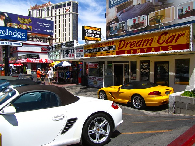
We hit the streets again, this time venturing into a few casinos/hotels, as well as some of the shops along the Strip.
My favorite was perhaps the Bellagio, with it's colorful ceiling made by glass artist Dale Chihuly. This swanky hotel also had a fun, themed sun room, which was decked out in whimsical floral art, complete with an aviary with colorful birds inside.


The Las Vegas Strip in the daytime was just as fun as at night — just much, much hotter. There were still people in ridiculous outfits clutching cups of alcohol in all shapes and sizes (my favorite? a drinking vessel shaped like a Guitar Hero guitar), and still plenty to do and see.
I think we were both sad when we couldn't put off leaving any longer. We will most definitely need to make a return trip in the not-so-distant future!


And as for our Utah plans? Well, I guess Zion will just have to wait until next time.
Each day, I’ll be cutting together a quick video to show you what we’ve been up to. Here’s Day 11 and 12. Excuse the lack of Vegas video — I didn't take my video camera out with me.
Road Trip Day 13 – Sweating My Face Off at Arches National Park
Since we missed out on Zion National Park in Utah, I wanted to make sure we devoted plenty of time to Arches National Park, near the town of Moab.
What I failed to take into consideration, however, is that most of the arches that make Arches famous require hiking to see. And it was August. And sunny. And incredibly hot.


… Yeah, we probably didn't think this one through too well.

Instead of doing some of the longer hikes in the park (such as the hours-long hike out to the famous Delicate Arch), we instead opted to just drive through the entire park, stopping at all the viewpoints, and doing a few of the shorter hikes to some of the more accessible arches.

Well, I should say that I did a few of the shorter hikes, while Melissa sat in the car most of the time.

I'm not saying I didn't enjoy Arches — because I did. It's a really worthwhile national park, with plenty of cool rocks and arches to see and climb. It's just that I hadn't planned on losing roughly 10 pounds in sweat while exploring it.

But, once I started getting all gross and sweaty, I figured the only option was to keep going. So, armed with more water than I've ever drunk before in a 4-hour span, I tackled the following at Arches:
PARK AVENUE — Okay, so this one really required no “tackling,” as I didn't actually do the hike here. Melissa and I just hopped out of the car at the lookout, and got our first taste of the red rocks of Arches.

BALANCED ROCK — A quick 10-minute walk here loops around an interesting rock formation — a gigantic boulder balancing on a pillar of rock.


The path around Balanced Rock is lined with dozens — maybe even hundreds — of cairns, man-made piles of stones that are often left behind by hikers to mark trails. I don't really think this trail needs any more marking, however. At this point, I think people build them just for fun, and to add to the collection.


THE WINDOWS SECTION — The Windows Section was one of the longer hikes that I did (and the beginning of Melissa's relaxing stint in the car). The whole loop around this section is 1 mile, and the estimated hike time is set at 30-60 minutes, which was pretty dead-on.
I went first to the North Window, which was the toughest part of the hike. It was all out in the baking sun, and all uphill. Granted, it wasn't very steep… but the hill plus the heat plus the high altitude had me sweating and panting in no time.

I took a break in the shadow of the North Window arch before continuing on.

Next came the South Window.

And then, lastly, Turret Arch. Part of me really wanted to climb through this one, but I was beat by this point, and had already drunk my bottle of water.

I settled for turning around and getting a view of both the Windows — a view some people call “The Eyeglasses.”)

DOUBLE ARCH — Not far from the Windows section sits Double Arch. Which you can probably figure out from its name. A gentle 5-10-minute walk gets you out to this arch.

If you climb through Double Arch, you can also see the Cove of Caves. Melissa and I, however, opted to sit in the shade and watch some guy propose to his girlfriend.

PANORAMA POINT — This was just a lookout. It did, indeed, give a pretty cool panorama of the park.

DELICATE ARCH VIEWPOINT — The half-mile hike to the Delicate Arch viewpoint doesn't sound too bad on paper. But once you get going and realize that it is entirely uphill (like, climbing a small mountain uphill), the hike becomes a lot less fun. But, I wasn't about to tackle to popular 3-mile hike out to the arch itself on such a hot day, so I forced myself to climb this damn hill.

Was it worth it? Probably.


FIERY FURNACE — This was another viewpoint, although you can take Ranger-led hikes through this labyrinth of narrow canyons. The area is named because, at certain times of day, the sun hits the rocks just right and makes them look like they're on fire. The day we were there, I would have said the whole park could have been called Fiery Furnace.


SKYLINE ARCH — You can hike out to this arch on an easy path that will take about 15 minutes round-trip, but we opted to just look at it from the car. By this point, we were pretty tired. And hungry.

SAND DUNE ARCH — As we drove through the Arches campground to turn around and head back out of the park, we came upon a French couple trying to hitchhike a ride back to their car. They had done a 40-minute hike, and didn't want to hike another hour back. So we squashed them in on top of all our stuff, and drove them back to Sand Dune Arch. Here, they suggested we do the easy 5-minute hike to the arch, which winds through a little slot canyon. We decided to do it.


It was actually probably my favorite arch in the park. The arch itself wasn't that exciting, but the short hike was in the shade, and the ground underfoot was covered in deep, cool sand. The kind of sand that's soft and fine and makes you just want to lay down in it.


It was definitely a great way to end our day at Arches.

So would I recommend a trip to Arches National Park? Absolutely. But I would not recommend it on a sunny August day. At least, not if you actually plan to get out of your car.

Each day, I’ll be cutting together a quick video to show you what we’ve been up to. Here’s Day 13:
Road Trip Day 14 – Who Says You Can't Enjoy a Ski Resort in the Summer?
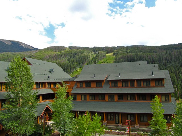
After having zipped around for many days without a break, we were both really looking forward to spending 2 nights in one place. And that one place happened to be beautiful Keystone, Colorado.

Keystone is up in the Rocky Mountains — probably not a destination most people would consider for a summer getaway. And, indeed, there was hardly anyone in this little ski resort town in August (the gas station didn't even have any gas!). But that may have made us love it even more.

After a twisting drive through the mountains and through the small city of Dillon, we arrived in Keystone — the sleepy resort town tucked up in the mountains.
At first, the Rockies didn't seem all that impressive. Even though there were still traces of snow on some of the peaks, the mountains just seemed… small. But then I reminded myself that we were already up above 9,000 feet, and the Rockies reached much higher than that. … Yes, THESE are mountains.

But, being more than 9,000 feet above sea level, it meant that the 100-degree temperatures we had just suffered in Utah were long gone. In fact, as we roamed around the resort that night, Melissa and I were actually chilly in our jeans and longsleeves. Thankfully, we had decided to pack them.

Our adventures in Keystone itself were not all that exciting. We had a very nice dinner at a fancy restaurant (where we ate things like buffalo and elk), then roamed around the lakeshore area. In the winter, this lake is an ice skating rink. During the warmer months, however, it becomes a place for ducks to float around and for eager fishermen to practice their fly fishing.

Most of the businesses here were quiet, but it was beautiful walking around, even under cloudy skies. I can only imagine how completely different the energy would be here during the winter months.

Our final Keystone highlight was taking the chair lift up the mountain in front of our condo (yes, did I mention we cozied up in a condo for 2 nights?) for some great views of the surrounding mountains.

Even though there's no snow this time of year, the chairlifts and gondolas still run — both for tourists like us, and for mountain bikers looking to tackle the trails that Keystone sets up in the mountains during the summer. It was strange to see people clad in knee pads and towing bicycles riding the chair lift to the top of the mountain. But it's actually a great idea.

And the views from the top? Unbeatable.

I'm already looking forward to going back to Keystone next summer for TBEX!
Each day, I’ll be cutting together a quick video to show you what we’ve been up to. Here’s Day 14:
Road Trip Day 15 – Adventure in the Rocky Mountains
I don't think any bout of travel would be complete without getting the adrenaline pumping at least a little bit. (This coming, of course, from someone who has been bungy jumping 3 times!)
So when my sister and I decided to add Colorado to our road trip plans, we knew we'd have to have some fun in the Rocky Mountains. And, staying in Keystone meant we had a lot of activities to choose from.

On Day 15, we woke up early to drive roughly an hour to a little outpost near Buena Vista, Colorado. The drive twisted and turned through the Rockies, and included at least one mountain pass that was above 10,000 feet. Did I mention I love mountains?

From the outpost, Arkansas Valley Adventures operates all sorts of adventure activities, from zip lining to whitewater rafting. We were booked on a full-day zip lining and rafting tour, and arrived early so we could check in and start getting our gear.

We began the morning with a couple of hours on the zip lining course, which is relatively brand new (this is its first season in operation). There are currently 5 zip lines on the course — all with fantastic views out over the valley.

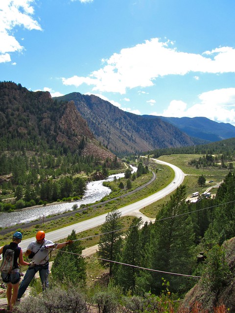

It was the first time my sister and I had been zip lining, but our guides for the morning were great, and we had no problems catching on. In fact, nobody in our group had any major issues on the course, though we did get a bit of training beforehand on what to do if we found ourselves in trouble (the term “self-rescue” was used a lot).
Thankfully, though, nobody needed any sort of rescuing, and the morning was a lot of fun. (Though I will say that the short hike up the mountain to the first zip line made me acutely aware of how high up in elevation we were! I was out of breath in like a minute.)


After zip lining, we were fed lunch, and then given about 2 hours to relax before we would yet again gear up for more adventure.

Melissa and I took a short drive to Buena Vista so we could check out the nearby range of “Fourteeners,” or mountains with summits that are above 14,000 feet. There are an abundance of them around this area, and they really were a sight to see. Some even still had traces of snow on them, even in mid-August.
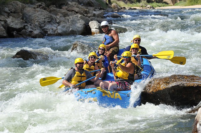
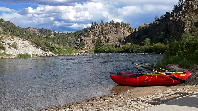
Returning to the AVA outpost in the afternoon, we donned life vests and helmets and clambered into an old school bus with about 16 other people in preparation for whitewater rafting on the Arkansas River.

AVA offers a variety of rafting options on the Arkansas, from relaxing float trips to challenging Class 5 rafting. My sister and I — being beginners — were signed up to raft about 11 miles of the river with Class 2 and 3 rapids. (Though, we were later told by a guide that, since the river level was so low, the rapids were all closer to being Class 2.)
It was about a 20 minute ride out to the launch point a few miles upstream of Browns Canyon, where we divided up into smaller groups and met our raft guides for the afternoon.

Our boat's guide, Brandon, went over all the safety instructions with us and taught us all the commands we would need to know to successfully paddle our way through all the rapids.
Right away, I knew Brandon would be a great guide. Not only did he know the river well (this was his second season working with AVA as a guide), but he was young, excited, and seemed to have a good sense of humor (for example, he told us that while he did not encourage trying to push each other out of the boat, he did encourage both crying and heckling/splashing other boats).

The first few miles of the river were fairly calm, so we used the time to get our paddling down right and get to know each other a bit better. It wasn't until we were entering Browns Canyon that the water started getting rougher.
Let me be upfront and tell you that whitewater rafting can definitely be dangerous. You are not strapped into your boat, and people DO fall out. Rafting also will probably make you sore if you're not used to wielding a paddle for hours at a time.
But it's also incredibly fun.

Once we started hitting the rapids, the time seemed to fly by, and we had a blast on the river. Sure, the rapids weren't very huge, but it was still a rush diving through them and bouncing off rocks.
Since our boat was full of (relatively) physically fit adults, Brandon had some fun with us and took some lines down the river that he doesn't normally take — including going through a few rapids sideways, or even backwards.

We definitely had the best guide.

As we approached each rapid, Brandon would tell us its name (or sometimes its nickname, like “Hemorrhoid Rock, because it's a real pain in the ass“), and tell us which way to swim if we fell out of the boat. There was always that anticipation before each rapid to see if anyone was going to become a “swimmer.”
But, everyone stayed in the boat. Brandon was actually a little disappointed by this, and attempted to flip us all over during the last 100 yards or so of the river. We, however, had other ideas — like staying out of the chilly water. We threatened to throw him in instead.
The only people who got wet were those who decided to cliff jump into the river at the only stop we made during the trip. One of the guides even launched himself off the cliff in a tiny kayak (see the video), though I would not recommend anyone else trying it!


So, was rafting the adrenaline-inducing activity I hoped it would be? Yes and no. It was a ton of fun, but it would have been much scarier had the river been higher (we were rafting at the very end of the season, when all the snowmelt had already gone).
But, thanks to some great guides and fun companions, Day 15 stands out as one of my favorite days during this road trip.

Each day, I’ll be cutting together a quick video to show you what we’ve been up to. Here’s Day 15:
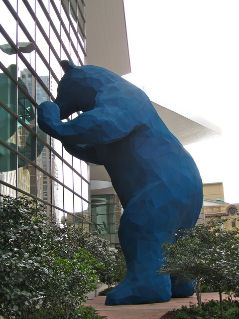
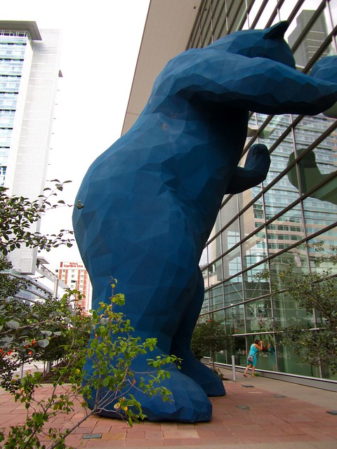
Road Trip Day 16 – Silliness Ensues in Denver
Maybe it's because we had been on the road for more than two weeks and had already covered more than 5,000 miles. Maybe we had been at a high altitude for one day too long. Or maybe it was just something in the air that day.
Whatever the explanation, there's no arguing that my sister and I had a bit of a strange day in Denver, Colorado.
The morning started out a bit tense, with us leaving Keystone late, and missing a lunch date with a Denver travel blogger whom I had really been looking forward to meeting. All that bad energy, however, was soon put in to having fun in this mile-high city.
We didn't have a long time to spend in Denver. In fact, it was basically just a lunch stop in between the Rocky Mountains and Nebraska. We had wanted to spend a whole day in Colorado's capital, but our schedule was simply already packed too tightly. So we had to make the most of the afternoon that we had.
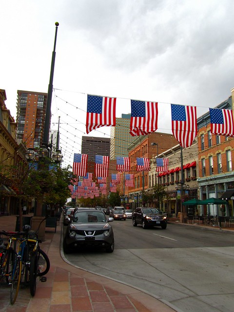
Since we couldn't have lunch at the oldest restaurant in Denver (which sports far too many dead animal heads on its walls), we opted, instead, for the infamous Wazee Supper Club in Lower Downtown (or LoDo, which Melissa got a kick out of repeating over and over). The Wazee Supper Club is a neat little diner with a lot of history and a vintage feel that is marketed as being “retro-urban.”
Well, I don't care what you call it — the place makes some damn good pizza!

We ordered a “Bianca-style” pizza, which was a white pizza with olive oil and spices in the place of tomato sauce. We topped it off with pepperoni and meatball slices (yes, meatball!). It was delicious.
Then it was time to take a stroll around downtown Denver, hoping that the storm clouds would hold off (they did).

Denver seems like a very hip, fun city. It didn't really feel huge, which I liked about it. But I would need to spend more than just a couple of hours there to really form an opinion.
As it was, though, Denver definitely prompted us to tap into our silly side:
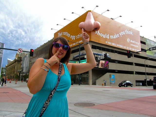
After the giant nose, we figured we couldn't possibly top that, and decided to end our Denver adventure on a high note. I definitely need to come back here soon.

And, sorry, but I don't have a video for you for Day 16. There simply wasn't enough time. Plus, you don't really want to watch a video of me picking my nose, do you?
Road Trip Day 17 – Nebraska, I Can't Decide if I Love You or Hate You
Have you ever visited a place where, one day you hated it, and the next you felt like maybe you were being too harsh on it?
That's kind of how it was for me and Nebraska.
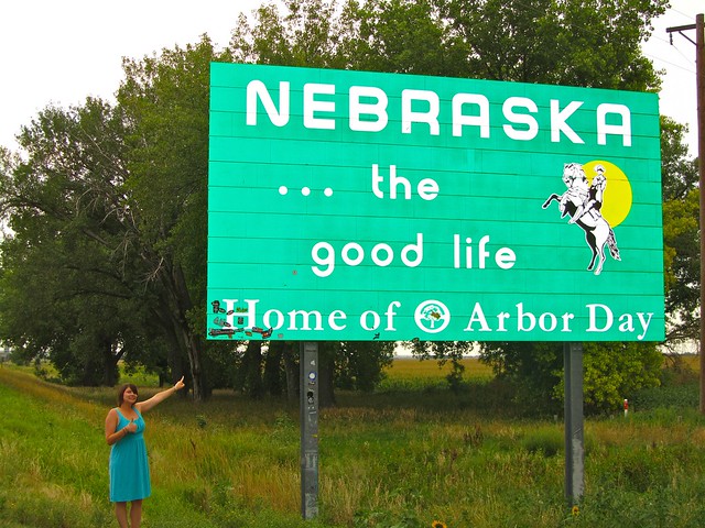
Everyone warned me that driving through Nebraska would suck. They said it was flat. And boring. And flat. And they were absolutely right.
Nebraska certainly won't win any awards for interesting or scenic drives. Driving 6+ hours across this state felt like it took days. And it didn't help that all the farmers had apparently just fertilized their fields, which meant that the whole state also smelled like cow manure. Lovely.
When we arrived in Kearney, roughly halfway across the state, my sister and I both had no love for Nebraska. We spent about 15 minutes trying to scrape dead bugs off our windshield, and deemed the state to be the worst we had visited yet.
But I'm never one to completely write a place off.

Since we knew Iowa was up next and that it likely would be very similar to Nebraska, I decided to try and find something for us to do in Kearney to break up the monotony. A quick Internet search came up with the Great Platte River Road Archway Monument.

Its name really doesn't do a very good job of describing what this place is — yes, it's a big archway (resembling a covered bridge) that stretches across I-80, but it's actually much more than that.
In fact, this place totally redeemed Nebraska for us.
Between 1843 and 1869, roughly half a million men, women and children rode and walked the trails to the West Coast. You know, those pioneer trails you learned about in middle school: The Mormon Trail, the California Trail, the Oregon Trail… And it just so happens that all of these trails converged at Fort Kearney — the last stop before the pioneers really set forth into “the unknown.”
The Archway Monument was built to pay tribute to “the enduring spirit of the pioneers” by bringing the westward migration to life through a multimedia smorgasbord that's essentially all about travel. Could there be a more perfect place to visit for two sisters on a road trip out West??

For a $10 admission fee, we got to go on an interactive adventure through history, complete with an audio tour, film clips, computer graphics, light and sound, life-size dioramas, re-enactors and classic cars. Within a couple of hours, we traversed through over 150 years of American history — a history that focused solely on the way people have traveled across our country.
If you grew up in the '90s, chances are you played the computer game Oregon Trail at least once. Or (if you were like me), perhaps hundreds of times. You forded rivers with your oxen, hunted for buffalo, and probably lost at least one person in your party to cholera or dysentery. But playing the game didn't really give you a sense of what it was like for the people who actually braved these journeys.
But the Archway Monument does.
Drawing from diary entries and stories from the people who survived the westward migration, this interactive museum actually helps you understand what it was like to traverse the Oregon Trail or Mormon Trail.

From there, the monument moves along through history, from train travel to the invention of the automobile to the advent of roads and the very first cross-country road trips. How fitting.

What began as a way to just kill some time in Nebraska turned into one of our favorite stops on our road trip. Totally worth $10.
It just goes to show you that even flat, boring, stinky places can still offer up something worth doing, if only you're willing to dig a little deeper.
Each day, I’ll be cutting together a quick video to show you what we’ve been up to. Here’s Day 17:
Road Trip Day 18-19: The End of the Road
From Nebraska, Melissa and I scooted on through Iowa, skirting miles and miles of cornfields and stopping at the “World's Largest Truck Stop” right before the Illinois border.
Is it really the world's largest? Who knows. It certainly was interesting, though, in an incredibly random way. Not only did the huge truck stop sell all sorts of flashy lights and leather interiors perfect for “pimping” your semi, but also pillow pets, machetes, and just about everything else in between.

From Iowa, it was on to Chicago. Both my sister and I have been to Chicago before, so we spent our first night there meeting up with a couple of my friends and gorging ourselves on macaroni and cheese and chicken tortilla soup from Feast. It was delicious.
The next day, being the last one of our trip, we headed down to Millennium Park for a bit since it was nice out and my sister had never been there before.


I've only been to Millennium Park in the dead of winter, so it was fun to see it so alive and bustling.

There were so many cute kids in adorable bathing suits screaming and having a blast that I could have easily stayed there all day.
But, after splashing around a bit in the fountains and grabbing lunch with another Chicago friend of mine, it was sadly time for us to bid the Windy City farewell. I really have no clue where the time went on this trip.

Unfortunately, no one warned us that “rush hour” in Chicago extends well into the afternoon. We spent two hours traversing about 30 miles on I-90 around the city. Oops. Good thing my car gets decent gas mileage…

And now for the very last daily road trip video from this adventure.
If you, too, are considering a summer road trip across the U.S. sometime, I cannot recommend it highly enough.

Amanda Williams is the award-winning blogger behind A Dangerous Business Travel Blog. She has traveled to more than 60 countries on 6 continents from her home base in Ohio, specializing in experiential and thoughtful travel through the US, Europe, and rest of the world. Amanda only shares tips based on her personal experiences and places she's actually traveled!


I’ve always wanted to do an American road trip like you’ve done. I’m from the UK but I’ve been to Orlando, FL and to San Diego, CA on vacations. It’s not the same beast at all though. I should make the move now that there’s no pandemic restrictions in place anymore.
[…] you’re planning to stop off at at least a few quirky roadside attractions. Whether it’s a town dedicated to Santa, a graveyard for cars, or some funky museum, the Roadside America app will give you plenty of […]
Hello Amanda, great video, it kinnda depresses me a little, I desperately need a vacation or at least a road trip or something!!!
I’m not a big fan of seeing other people traveling and such but I gotta tell you I really like your blog, keep it up.
Bye.
Thanks so much, Cristian. Hopefully I’m not making you TOO envious!
This is part of the US that I know nothing about. Such interesting places. Great job with the video!
I don’t know much about this part of the US, either, so it’s fun to get the chance to explore it a bit! And thanks for the compliment on my video. It’s definitely a learned process, trying to do one of these each day!
Great article and great start to this series. I had no idea that Churchill Downs built a statue to honor the late Barbaro. Very touching. Great photos!
Thanks, Bob! And yes, Barbaro is actually buried there, in front of the racetrack. I didn’t know they had built that statue, either, but it was definitely a nice touch.
thats a lot of border crossings! love the images it looks like you had a fantastic trip!
http://sandbetweentoes.wordpress.com/
Yup, 5 state borders in one day isn’t too shabby!
You covered a lot of ground on Day 1. And it is always a successful day when you run across something bazaar in small town America.
Yes, we did a lot of driving on our first day! But it actually wasn’t bad at all. Then we took a break on Day 2. 🙂 And yes, small town America certainly does lend itself to some weird discoveries!
The derby museum looked like fun. I love interactive museums. Your first day was definitely successful if you stumbled upon a town called Santa Claus! How funny is that. 🙂
Yes it was really interactive and fun, yet still interesting at the same time. I think kids would even love it.
And stumbling upon Santa Claus, IN, was awesome.
Looks like a great start! I am completely unsurprised there is a santa claus, indiana. If anything, I am surprised it is not in Kansas, where towns really try to rope people in from the highway. I wonder what santa claus, IN is like during Christmas?? If you like BBQ, check out http://www.pappyssmokehouse.com/ in st. louis. It was the best barbeque I’ve ever had.
My sister and I were wondering what Santa Claus, IN, would be like at Christmas, too. We’re pretty sure it’s probably really over-the-top.
Great Day One! I’ve gone out west so many times, my usual day one is all driving- making that long one day jump across the Great Plains. Looking forward to following the rest of the journey!
We purposefully stretched out our trip so that, on average, we’ll only be doing about 6 hours of driving per day. We did about 9 hours on Day 1, but broke it up into two big chunks, so it really didn’t seem too bad at all!